Geolocate

Bethlehem topographic map

Click on the map to display elevation.

Bethlehem

The city lies at an altitude of 1,700 metres (5,600 ft) and this contributes to its cool climate with frosty winters and mild summers. The average annual temperature is around 14 °C (57 °F).

Wikipedia (CC-BY-SA 3.0)

About this map

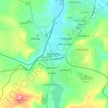
Name: Bethlehem topographic map, elevation, terrain.

Location: Bethlehem, Dihlabeng Local Municipality, Thabo Mofutsanyana District Municipality, Free State, 9700, South Africa (-28.27083 28.26889 -28.19083 28.34889)

Average elevation: 1,675 m

Minimum elevation: 1,605 m

Maximum elevation: 1,838 m

Gear up for your next adventure:

🧴Sport Sunscreen Sticks - High-protection sunblock that won't run into your eyes on the trail
🥾Walking Shoes - Lightweight walking shoes for countryside and coastal paths
📐Altimeters & Barometers - Tools for measuring altitude and air pressure
🎒Hiking Daypacks (20L) - Compact backpacks for day trips and technical mountain ascents
🐕Dog Hiking Gear - Equipment for hiking safely with dogs

As an Amazon Associate, this site earns from qualifying purchases at no extra cost to you.