Geolocate

Kronach topographic map

Click on the map to display elevation.

About this map
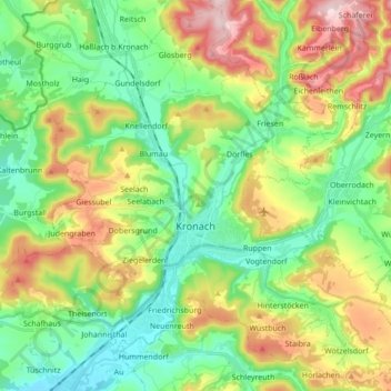
Name: Kronach topographic map, elevation, terrain.

Location: Kronach, Landkreis Kronach, Bavaria, 96317, Germany (50.19341 11.26470 50.30324 11.41768)

Average elevation: 394 m

Minimum elevation: 287 m

Maximum elevation: 587 m

Other topographic maps

Click on a map to view its topography, its elevation and its terrain.

Tschirn

Germany > Bavaria > Landkreis Kronach > Tschirn

Average elevation: 613 m

Gear up for your next adventure:

🥼Base Layers - Thermal base layers for temperature regulation
🧥Packable Down Jackets - Lightweight warmth that compresses small in your bag
📻Hand-Crank Emergency Radios - Stay updated on weather warnings in remote areas
🥫Expedition Meals - Lightweight, high-calorie nutrition for long-distance hikers
🛰️Handheld GPS Devices - Reliable GPS units for hiking and outdoor navigation

As an Amazon Associate, this site earns from qualifying purchases at no extra cost to you.