
Make a donation
Gear up for your next adventure:
As an Amazon Associate, this site earns from qualifying purchases at no extra cost to you.
Cantón Poás topographic map
Click on the map to display elevation.
Make a donation
Gear up for your next adventure:
As an Amazon Associate, this site earns from qualifying purchases at no extra cost to you.
Cantón Poás
Poás has an area of 73.84 km² and a mean elevation of 1,184 metres.
Make a donation
Gear up for your next adventure:
As an Amazon Associate, this site earns from qualifying purchases at no extra cost to you.
About this map
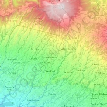
Name: Cantón Poás topographic map, elevation, terrain.
Location: Cantón Poás, Alajuela Province, Costa Rica (10.01435 -84.29947 10.19776 -84.19558)
Average elevation: 1,430 m
Minimum elevation: 672 m
Maximum elevation: 2,688 m
Make a donation
Gear up for your next adventure:
As an Amazon Associate, this site earns from qualifying purchases at no extra cost to you.
Other topographic maps
Click on a map to view its topography, its elevation and its terrain.