Geolocate

Plauen topographic map

Click on the map to display elevation.

About this map
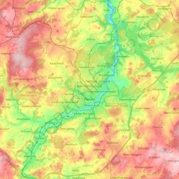
Name: Plauen topographic map, elevation, terrain.

Location: Plauen, Vogtlandkreis, Saxony, Germany (50.43067 12.05941 50.57486 12.22946)

Average elevation: 429 m

Minimum elevation: 300 m

Maximum elevation: 553 m

Other topographic maps

Click on a map to view its topography, its elevation and its terrain.

Gippe

Germany > Saxony > Vogtlandkreis > Elsterberg

Average elevation: 358 m

Mühlleithen

Germany > Saxony > Vogtlandkreis > Klingenthal

Average elevation: 825 m

Röthenbach

Germany > Saxony > Vogtlandkreis > Bad Brambach > Hohendorf

Average elevation: 641 m

Gear up for your next adventure:

🔦Outdoor Torches - Reliable torches for night navigation
🎿Telescopic Trekking Poles - Reduces knee strain on steep topographic descents
🌄Compact Monoculars - Lightweight optics for hiking
🔋Solar Power Banks - Keep your GPS and phone charged during multi-day expeditions
📱Phone Mounts for Hiking - Secure mounts to carry your phone on trails

As an Amazon Associate, this site earns from qualifying purchases at no extra cost to you.