Geolocate

Nauzon topographic map

Click on the map to display elevation.

About this map

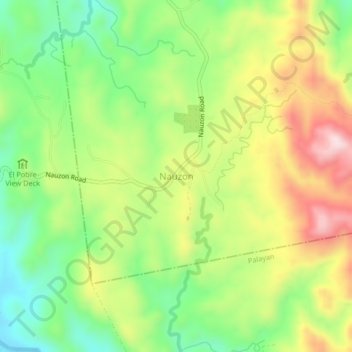
Name: Nauzon topographic map, elevation, terrain.

Location: Nauzon, Nueva Ecija, Central Luzon, Philippines (15.44573 121.12354 15.48573 121.16354)

Average elevation: 262 m

Minimum elevation: 107 m

Maximum elevation: 463 m

Other topographic maps

Click on a map to view its topography, its elevation and its terrain.

Cuyapo

Philippines > Nueva Ecija

Average elevation: 41 m

Peñaranda

Philippines > Nueva Ecija

Average elevation: 39 m

Aliaga

Philippines > Nueva Ecija

Average elevation: 26 m

Quezon

Philippines > Nueva Ecija

Average elevation: 28 m

Gear up for your next adventure:

🎒Hiking Backpacks - Comfortable backpacks for day hikes and multi-day treks
📻Hand-Crank Emergency Radios - Stay updated on weather warnings in remote areas
🎒Backpack Rain Covers - Universal waterproof covers to protect your gear from downpours
📕Outdoor Navigation Books - Learn traditional and modern navigation techniques
🥾Hiking Boot Waterproofing Wax - Maintain the lifespan of your leather trekking boots

As an Amazon Associate, this site earns from qualifying purchases at no extra cost to you.