
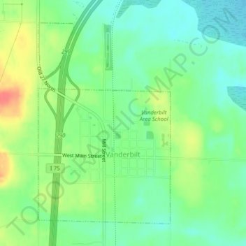
Vanderbilt topographic map
Interactive map
Click on the map to display elevation.
About this map
Name: Vanderbilt topographic map, elevation, terrain.
Average elevation: 334 m
Minimum elevation: 313 m
Maximum elevation: 369 m
Other topographic maps
Click on a map to view its topography, its elevation and its terrain.
Chester Township
United States > Michigan > Otsego County
Chester Township, Otsego County, Michigan, United States
Average elevation: 392 m
Charlton Township
United States > Michigan > Otsego County
Charlton Township, Otsego County, Michigan, 49751, United States
Average elevation: 368 m
Apache Lake
United States > Michigan > Otsego County
Apache Lake, Bagley Township, Otsego County, Michigan, United States
Average elevation: 392 m
Pigeon River Country State Forest
United States > Michigan > Otsego County
Pigeon River Country State Forest, Otsego County, Michigan, United States
Average elevation: 289 m
Gaylord
United States > Michigan > Otsego County > Gaylord
Gaylord, Otsego County, Michigan, United States
Average elevation: 401 m