
Town of Indian Lake topographic map
Interactive map
Click on the map to display elevation.
About this map
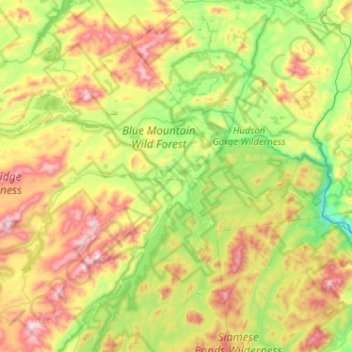
Name: Town of Indian Lake topographic map, elevation, terrain.
Average elevation: 625 m
Minimum elevation: 318 m
Maximum elevation: 1,160 m
Indian Lake has a humid continental climate (Dfb), although it is much colder than most of New York due to its high elevation and northern location. Winters are cold and snowy, while summers are warm and humid. Precipitation is abundant year round, but peaks in summer. The coldest month is January, with a mean temperature of 15.4, while the warmest month is July with a mean of 63.8. Just 0.1 day per year exceeds 90, with the last such instance coming in 1988. Days in the 80s are also relatively uncommon, with an average of just 18 per year. The record high is 105 in June 1919, but the temperature has not exceeded 95 since 1935. The record low is -42 in January 1908. The coldest temperature in a typical year is -22, putting Indian Lake in hardiness zone 4B. The record low high is -12 in 1968, while the record high low in a day is 74 in 2006.