Geolocate

Ennice topographic map

Click on the map to display elevation.

About this map
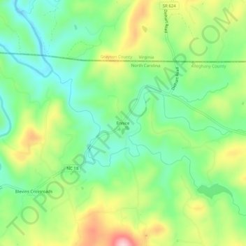
Name: Ennice topographic map, elevation, terrain.

Location: Ennice, Alleghany County, North Carolina, 28623, United States (36.53346 -81.01591 36.57346 -80.97591)

Average elevation: 794 m

Minimum elevation: 705 m

Maximum elevation: 944 m

Other topographic maps

Click on a map to view its topography, its elevation and its terrain.
Sparta

United States > North Carolina > Alleghany County

Average elevation: 893 m

Sparta

United States > North Carolina > Alleghany County

Average elevation: 893 m

Sparta

United States > North Carolina > Alleghany County

Average elevation: 893 m

Sparta

United States > North Carolina > Alleghany County

Average elevation: 893 m

Gear up for your next adventure:

🦟Anti-Midge & Tick Repellent - Vital for hiking in the Scottish Highlands during summer
🧤Hiking Gloves - Warm and durable gloves for cold-weather walks
🍱Food Containers - Reusable containers for outdoor meals
⛺Camping Shelters - Emergency and lightweight shelters for outdoor use
🗺️Topographic Maps - Detailed maps showing elevation and terrain features

As an Amazon Associate, this site earns from qualifying purchases at no extra cost to you.