
Saint-Pierre-de-la-Rivière-du-Sud topographic map
Interactive map
Click on the map to display elevation.
About this map
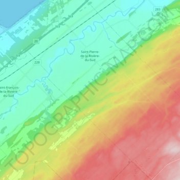
Name: Saint-Pierre-de-la-Rivière-du-Sud topographic map, elevation, terrain.
Average elevation: 134 m
Minimum elevation: -2 m
Maximum elevation: 384 m
Other topographic maps
Click on a map to view its topography, its elevation and its terrain.
Saint-Fabien-de-Panet
Canada > Quebec > Montmagny (MRC) > Saint-Fabien-de-Panet
Saint-Fabien-de-Panet, Montmagny (MRC), Chaudiere-Appalaches, Quebec, Canada
Average elevation: 438 m