Geolocate

Duy Xuyên District topographic map

Interactive map

Click on the map to display elevation.

About this map

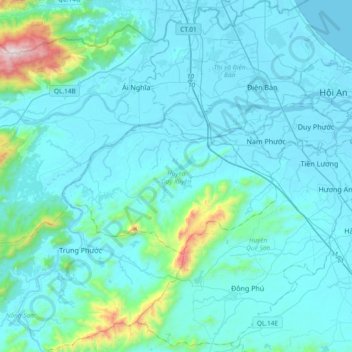
Name: Duy Xuyên District topographic map, elevation, terrain.

Location: Duy Xuyên District, Quang Nam Province, Vietnam (15.71394 108.03933 15.87288 108.41254)

Average elevation: 112 m

Minimum elevation: -1 m

Maximum elevation: 1,242 m

Other topographic maps

Click on a map to view its topography, its elevation and its terrain.

Duy Phước

Vietnam > Quang Nam Province > Duy Xuyên District

Duy Phước, Duy Xuyên District, Quảng Nam Province, 51506, Vietnam

Average elevation: 5 m

Sông Tam Kỳ

Vietnam > Quang Nam Province > Núi Thành District > Tam Kỳ City

Sông Tam Kỳ, Tam Kỳ City, Núi Thành District, Quang Nam Province, Vietnam

Average elevation: 13 m

Hoi An

Vietnam > Quang Nam Province > Hoi An

Hoi An, Hội An, Quang Nam Province, 0510, Vietnam

Average elevation: 25 m

Bà nà hills

Vietnam > Quang Nam Province > Đông Giang District

Bà nà hills, Đông Giang District, Quang Nam Province, Vietnam

Average elevation: 915 m

ffff

Vietnam > Quang Nam Province > Nam Trà My District

ffff, Nam Trà My District, Quang Nam Province, Vietnam

Average elevation: 463 m

Hội An

Vietnam > Quang Nam Province

Hội An, Quảng Nam Province, Vietnam

Average elevation: 4 m

sông Bàn Thạch

Vietnam > Quang Nam Province > Tam Kỳ City

sông Bàn Thạch, Tam Kỳ City, Quang Nam Province, Vietnam

Average elevation: 5 m

Núi Thành District

Vietnam > Quang Nam Province

Núi Thành District, Quang Nam Province, 0065, Vietnam

Average elevation: 129 m

ffff

Vietnam > Quang Nam Province

ffff, Nam Trà My District, Quang Nam Province, Vietnam

Average elevation: 454 m

Hiệp Đức District

Vietnam > Quang Nam Province

Hiệp Đức District, Quang Nam Province, Vietnam

Average elevation: 221 m