
Tha Phraya topographic map
Interactive map
Click on the map to display elevation.
About this map
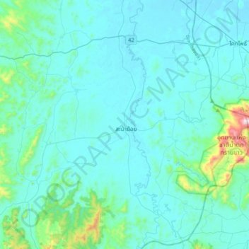
Name: Tha Phraya topographic map, elevation, terrain.
Location: Tha Phraya, Songkhla Province, Thailand (6.46530 100.78777 6.78530 101.10777)
Average elevation: 93 m
Minimum elevation: 2 m
Maximum elevation: 976 m
Other topographic maps
Click on a map to view its topography, its elevation and its terrain.
Na Mom
Na Mom, Ban Rai, Songkhla Province, 90310, Thailand
Average elevation: 43 m
Upper Level. Highest accessible level. You won't see Amy other visitors. Good place to take a swim.
Upper Level. Highest accessible level. You won't see Amy other visitors. Good place to take a swim., Songkhla Province, Thailand
Average elevation: 397 m
Hat Yai
Hat Yai, Kho Hong, Songkhla Province, Thailand
Average elevation: 47 m
Ban Phru
Ban Phru, Ban Rai, Songkhla Province, 90230, Thailand
Average elevation: 31 m