
Thank you for supporting this site ❤️
Make a donation
Make a donation
Gear up for your next adventure:
As an Amazon Associate, this site earns from qualifying purchases at no extra cost to you.
Olmos topographic map
Click on the map to display elevation.
Thank you for supporting this site ❤️
Make a donation
Make a donation
Gear up for your next adventure:
As an Amazon Associate, this site earns from qualifying purchases at no extra cost to you.
About this map
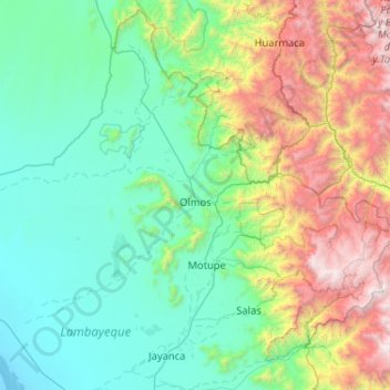
Name: Olmos topographic map, elevation, terrain.
Location: Olmos, Province of Lambayeque, Lambayeque, Peru (-6.45895 -80.62713 -5.48039 -79.59296)
Average elevation: 877 m
Minimum elevation: -3 m
Maximum elevation: 4,097 m
Thank you for supporting this site ❤️
Make a donation
Make a donation
Gear up for your next adventure:
As an Amazon Associate, this site earns from qualifying purchases at no extra cost to you.