
Thank you for supporting this site ❤️
Make a donation
Make a donation
Gear up for your next adventure:
As an Amazon Associate, this site earns from qualifying purchases at no extra cost to you.
Ponteareas topographic map
Click on the map to display elevation.
Thank you for supporting this site ❤️
Make a donation
Make a donation
Gear up for your next adventure:
As an Amazon Associate, this site earns from qualifying purchases at no extra cost to you.
About this map
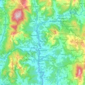
Name: Ponteareas topographic map, elevation, terrain.
Location: Ponteareas, O Condado, Pontevedra, Galicia, Spain (42.11015 -8.58818 42.26681 -8.41595)
Average elevation: 192 m
Minimum elevation: 10 m
Maximum elevation: 736 m
Thank you for supporting this site ❤️
Make a donation
Make a donation
Gear up for your next adventure:
As an Amazon Associate, this site earns from qualifying purchases at no extra cost to you.