
Buchrain topographic map
Interactive map
Click on the map to display elevation.
About this map
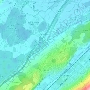
Name: Buchrain topographic map, elevation, terrain.
Location: Buchrain, Lucerne, 6033, Switzerland (47.08806 8.32769 47.11563 8.36542)
Average elevation: 429 m
Minimum elevation: 411 m
Maximum elevation: 541 m
Other topographic maps
Click on a map to view its topography, its elevation and its terrain.
Schloss Meggenhorn
Switzerland > Lucerne > Meggen
Schloss Meggenhorn, 53, Meggenhornstrasse, Lerchenbühl, Meggen, Lucerne, 6045, Switzerland
Average elevation: 450 m
Allmendhubel
Switzerland > Lucerne > Menznau
Allmendhubel, Allmend, Menznau, Lucerne, 6122, Switzerland
Average elevation: 636 m
Schachen
Switzerland > Lucerne > Werthenstein > Schachen
Schachen, Werthenstein, Lucerne, 6105, Switzerland
Average elevation: 671 m