
Fustat topographic map
Interactive map
Click on the map to display elevation.
About this map
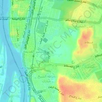
Name: Fustat topographic map, elevation, terrain.
Location: Fustat, Masr Al-Qadima, EL Sheikh Mubarak, Cairo, Egypt (30.00367 31.22957 30.01080 31.24035)
Average elevation: 29 m
Minimum elevation: 12 m
Maximum elevation: 56 m
Other topographic maps
Click on a map to view its topography, its elevation and its terrain.
Rhoda Island
Egypt > Cairo > Cairo > EL Sheikh Mubarak
Rhoda Island, EL Sheikh Mubarak, Cairo, Egypt
Average elevation: 26 m
Fostat garden
Egypt > Cairo > Cairo > EL Sheikh Mubarak
Fostat garden, Masr Al-Qadima, EL Sheikh Mubarak, Cairo, Egypt
Average elevation: 33 m