Geolocate

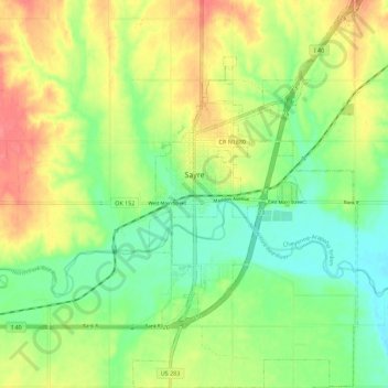
Sayre topographic map

Click on the map to display elevation.

Sayre

Sayre is located on the North Fork of the Red River, at an elevation of 1,800 feet (550 m) and 128 miles (206 km) west of Oklahoma City. The area is dominated by low rolling red clay hills.

Wikipedia (CC-BY-SA 3.0)

About this map

Name: Sayre topographic map, elevation, terrain.

Location: Sayre, Beckham County, Oklahoma, 73662, United States (35.24766 -99.65779 35.33907 -99.59298)

Average elevation: 567 m

Minimum elevation: 536 m

Maximum elevation: 605 m

Other topographic maps

Click on a map to view its topography, its elevation and its terrain.

Erick

United States > Oklahoma > Beckham County

Average elevation: 631 m

Elk City

United States > Oklahoma > Beckham County

Average elevation: 588 m

Elk City

United States > Oklahoma > Beckham County

Average elevation: 588 m

Gear up for your next adventure:

🥤Collapsible Water Bottles - Save space in your rucksack as you consume your water
🗺️Scratch-off Peak Maps - Track your progress climbing Munros or Wainwrights
🎒Hiking Daypacks (20L) - Compact backpacks for day trips and technical mountain ascents
☕Insulated Travel Mugs - Keep drinks hot while surveying the landscape from a summit
🔋Power Banks - Portable chargers for long outdoor trips

As an Amazon Associate, this site earns from qualifying purchases at no extra cost to you.