
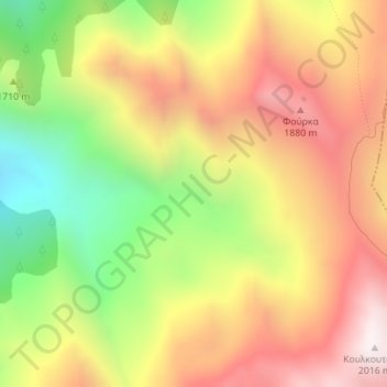
Pindus topographic map
Interactive map
Click on the map to display elevation.
About this map
Name: Pindus topographic map, elevation, terrain.
Average elevation: 1,510 m
Minimum elevation: 942 m
Maximum elevation: 2,013 m
Other topographic maps
Click on a map to view its topography, its elevation and its terrain.
Thessaly - Central Greece
Greece > Thessaly - Central Greece
Thessaly - Central Greece, Greece
Average elevation: 367 m
Kalambaka
Greece > Thessaly - Central Greece > Kalambaka
Kalambaka, Kalampaka Municipality, Regional Unit of Trikala, Region of Thessaly, Thessaly - Central Greece, 42200, Greece
Average elevation: 339 m
Karditsa
Greece > Thessaly - Central Greece > Karditsa
Karditsa, Δήμος Καρδίτσας, Karditsa Regional Unit, Region of Thessaly, Thessaly - Central Greece, 43100, Greece
Average elevation: 237 m
Touba (Mount Olympus)
Greece > Thessaly - Central Greece
Touba (Mount Olympus), Elassona Municipality, Regional Unit of Larisa, Region of Thessaly, Thessaly - Central Greece, Greece
Average elevation: 2,375 m
Regional Unit of Boeotia
Greece > Thessaly - Central Greece
Regional Unit of Boeotia, Region of Central Greece, Thessaly - Central Greece, Greece
Average elevation: 262 m
Lidoriki
Greece > Thessaly - Central Greece > Lidoriki
Lidoriki, Δήμος Δωρίδος, Regional Unit of Phocis, Region of Central Greece, Thessaly - Central Greece, 33053, Greece
Average elevation: 836 m
Kymi
Greece > Thessaly - Central Greece > Kymi
Kymi, Δήμος Κύμης - Αλιβερίου, Regional Unit of Euboea, Region of Central Greece, Thessaly - Central Greece, 34003, Greece
Average elevation: 192 m
Κ. Αυλακίου
Greece > Thessaly - Central Greece > Avlaki
Κ. Αυλακίου, Avlaki, Δήμος Στυλίδας, Regional Unit of Phthiotis, Region of Central Greece, Thessaly - Central Greece, 35100, Greece
Average elevation: 88 m
Alonnisos Municipality
Greece > Thessaly - Central Greece
Alonnisos Municipality, Regional Unit of Sporades, Region of Thessaly, Thessaly - Central Greece, 37005, Greece
Average elevation: 13 m
Trigia
Greece > Thessaly - Central Greece
Trigia, Kalampaka Municipality, Regional Unit of Trikala, Region of Thessaly, Thessaly - Central Greece, Greece
Average elevation: 1,889 m
Kato Ktimeni
Greece > Thessaly - Central Greece > Kato Ktimeni
Kato Ktimeni, Δήμος Σοφάδων, Karditsa Regional Unit, Region of Thessaly, Thessaly - Central Greece, 43063, Greece
Average elevation: 467 m
Φράγμα Μόρνου
Greece > Thessaly - Central Greece
Φράγμα Μόρνου, Δήμος Δωρίδος, Regional Unit of Phocis, Region of Central Greece, Thessaly - Central Greece, Greece
Average elevation: 519 m
Δημοτική Ενότητα Αραχώβης
Greece > Thessaly - Central Greece > Δημοτική Ενότητα Αραχώβης
Δημοτική Ενότητα Αραχώβης, Δήμος Διστόμου-Αράχοβας-Αντίκυρας, Regional Unit of Boeotia, Region of Central Greece, Thessaly - Central Greece, 32004, Greece
Average elevation: 1,198 m
Farsala
Greece > Thessaly - Central Greece > Farsala
Farsala, Farsala Municipality, Regional Unit of Larisa, Region of Thessaly, Thessaly - Central Greece, 40300, Greece
Average elevation: 215 m
Λουτρά Θερμοπυλών
Greece > Thessaly - Central Greece > Λουτρά Θερμοπυλών
Λουτρά Θερμοπυλών, Lamia, Regional Unit of Phthiotis, Region of Central Greece, Thessaly - Central Greece, 35009, Greece
Average elevation: 241 m
Kastraki
Greece > Thessaly - Central Greece > Kastraki
Kastraki, Volos Municipality, Regional Unit of Magnesia, Region of Thessaly, Thessaly - Central Greece, 37100, Greece
Average elevation: 117 m
Κ. Βράχας
Greece > Thessaly - Central Greece > Vracha
Κ. Βράχας, Vracha, Δήμος Καρπενησίου, Regional Unit of Evrytania, Region of Central Greece, Thessaly - Central Greece, 36080, Greece
Average elevation: 888 m
Agia Anna
Greece > Thessaly - Central Greece > Agia Anna
Agia Anna, Δήμος Μαντουδίου - Λίμνης - Αγίας Άννας, Regional Unit of Euboea, Region of Central Greece, Thessaly - Central Greece, 34010, Greece
Average elevation: 233 m
Perivolia
Greece > Thessaly - Central Greece > Perivolia
Perivolia, Δήμος Κύμης - Αλιβερίου, Regional Unit of Euboea, Region of Central Greece, Thessaly - Central Greece, 34009, Greece
Average elevation: 101 m
Κοινότητα Αντικύρας
Greece > Thessaly - Central Greece > Antikyra
Κοινότητα Αντικύρας, Antikyra, Δήμος Διστόμου-Αράχοβας-Αντίκυρας, Regional Unit of Boeotia, Region of Central Greece, Thessaly - Central Greece, 32012, Greece
Average elevation: 152 m
Chania
Greece > Thessaly - Central Greece > Chania
Chania, Δήμος Κύμης - Αλιβερίου, Regional Unit of Euboea, Region of Central Greece, Thessaly - Central Greece, 34009, Greece
Average elevation: 91 m
Karavas
Greece > Thessaly - Central Greece
Karavas, Δήμος Μουζακίου, Karditsa Regional Unit, Region of Thessaly, Thessaly - Central Greece, 43060, Greece
Average elevation: 402 m
Κοινότητα Δελφών
Greece > Thessaly - Central Greece > Delphi
Κοινότητα Δελφών, Delphi, Δήμος Δελφών, Regional Unit of Phocis, Region of Central Greece, Thessaly - Central Greece, 33054, Greece
Average elevation: 598 m