
Königswinter topographic map
Interactive map
Click on the map to display elevation.
About this map
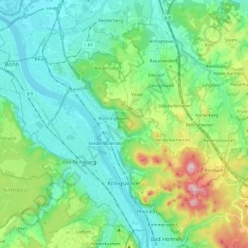
Name: Königswinter topographic map, elevation, terrain.
Average elevation: 137 m
Minimum elevation: 43 m
Maximum elevation: 433 m
Other topographic maps
Click on a map to view its topography, its elevation and its terrain.
Ruppichteroth
Germany > North Rhine – Westphalia > Rhein-Sieg-Kreis
Ruppichteroth, Rhein-Sieg-Kreis, North Rhine – Westphalia, 53809, Germany
Average elevation: 216 m