
Mwanza topographic map
Interactive map
Click on the map to display elevation.
About this map
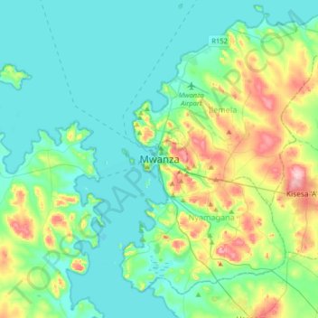
Name: Mwanza topographic map, elevation, terrain.
Location: Mwanza, Nyamagana, Mwanza Region, Lake Zone, 33214, Tanzania (-2.67969 32.74144 -2.35969 33.06144)
Average elevation: 1,178 m
Minimum elevation: 1,129 m
Maximum elevation: 1,346 m
Mwanza features a tropical savanna climate under the Köppen climate classification. Temperatures are relatively consistent throughout the course of the year, tempered by the city's altitude. Thus, the climate is not quite as hot as one might expect, given the city's location near the equator. Average temperatures in Mwanza is roughly 23.5 °C (74.3 °F) throughout the year. The city features a lengthy wet season which runs from October through May and a short pronounced dry season that covers the remaining four months. Mwanza receives on average roughly 1,050 millimetres (41 in) of precipitation annually.
Other topographic maps
Click on a map to view its topography, its elevation and its terrain.
Kisesa
Kisesa, Magu, Mwanza Region, Lake Zone, Tanzania
Average elevation: 1,170 m
Sima
Sima, Sengerema, Mwanza Region, Lake Zone, Tanzania
Average elevation: 1,202 m
Nyasato
Nyasato, Magu, Mwanza Region, Lake Zone, Tanzania
Average elevation: 1,232 m
Chifunfu
Chifunfu, Sengerema, Mwanza Region, Lake Zone, Tanzania
Average elevation: 1,140 m
Ilemela
Ilemela, Ilemela Municipal, Mwanza Region, Lake Zone, 33216, Tanzania
Average elevation: 1,206 m
Nyanguge
Nyanguge, Magu, Mwanza Region, Lake Zone, Tanzania
Average elevation: 1,156 m
Sangabuye
Sangabuye, Ilemela Municipal, Mwanza Region, Lake Zone, Tanzania
Average elevation: 1,156 m
Kahama
Kahama, Ilemela Municipal, Mwanza Region, Lake Zone, 33216, Tanzania
Average elevation: 1,249 m
Ukerewe
Ukerewe, Mwanza Region, Lake Zone, Tanzania
Average elevation: 1,151 m