
Make a donation
Gear up for your next adventure:
As an Amazon Associate, this site earns from qualifying purchases at no extra cost to you.
Grad Zabok topographic map
Click on the map to display elevation.
Make a donation
Gear up for your next adventure:
As an Amazon Associate, this site earns from qualifying purchases at no extra cost to you.
Grad Zabok
Zabok is located at 46°1′46″N 15°54′54″E / 46.02944°N 15.91500°E / 46.02944; 15.91500, at an altitude of 186 m above sea level. The following settlements comprise the town's administrative area.
Make a donation
Gear up for your next adventure:
As an Amazon Associate, this site earns from qualifying purchases at no extra cost to you.
About this map
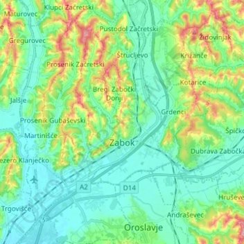
Name: Grad Zabok topographic map, elevation, terrain.
Location: Grad Zabok, Krapina-Zagorje County, 49210, Croatia (45.99707 15.85113 46.06846 15.97421)
Average elevation: 173 m
Minimum elevation: 134 m
Maximum elevation: 278 m
Make a donation
Gear up for your next adventure:
As an Amazon Associate, this site earns from qualifying purchases at no extra cost to you.
Other topographic maps
Click on a map to view its topography, its elevation and its terrain.
Make a donation
Gear up for your next adventure:
As an Amazon Associate, this site earns from qualifying purchases at no extra cost to you.