
Thousand Oaks topographic map
Interactive map
Click on the map to display elevation.
About this map
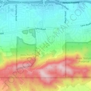
Name: Thousand Oaks topographic map, elevation, terrain.
Location: Thousand Oaks, Ventura County, California, United States (34.17084 -118.91146 34.17228 -118.90929)
Average elevation: 303 m
Minimum elevation: 191 m
Maximum elevation: 486 m
The northern parts consist of mountainous terrain in the Simi Hills, Conejo Mountains and Mount Clef Ridge. Narrow canyons such as Hill Canyon cut through the steeper mountainous areas. Conejo Mountain and Conejo Grade are found in westernmost Newbury Park, while the southernmost parts of Thousand Oaks are made up of Russell Valley, Hidden Valley and the steep rugged slopes of the Santa Monica Mountains. The elevation ranges from 500 feet in the northwest to the 2,403 feet Simi Peak. The major drainage is Conejo Creek (Arroyo Conejo).
Other topographic maps
Click on a map to view its topography, its elevation and its terrain.
Newbury Park
United States > California > Ventura County > Thousand Oaks > Newbury Park
Newbury Park, Thousand Oaks, Ventura County, California, 91320, United States
Average elevation: 262 m
Greenwich Village
United States > California > Ventura County > Thousand Oaks > Greenwich Village
Greenwich Village, Thousand Oaks, Ventura County, California, 91360-4401, United States
Average elevation: 275 m