
Thank you for supporting this site ❤️
Make a donation
Make a donation
Gear up for your next adventure:
As an Amazon Associate, this site earns from qualifying purchases at no extra cost to you.
Interlomas topographic map
Click on the map to display elevation.
Thank you for supporting this site ❤️
Make a donation
Make a donation
Gear up for your next adventure:
As an Amazon Associate, this site earns from qualifying purchases at no extra cost to you.
About this map
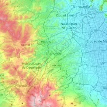
Name: Interlomas topographic map, elevation, terrain.
Location: Interlomas, Huixquilucan, 52760, Mexico (19.23586 -99.44126 19.55586 -99.12126)
Average elevation: 2,656 m
Minimum elevation: 2,230 m
Maximum elevation: 3,846 m
Thank you for supporting this site ❤️
Make a donation
Make a donation
Gear up for your next adventure:
As an Amazon Associate, this site earns from qualifying purchases at no extra cost to you.