
Make a donation
Gear up for your next adventure:
As an Amazon Associate, this site earns from qualifying purchases at no extra cost to you.
Dadeville topographic map
Click on the map to display elevation.
Make a donation
Gear up for your next adventure:
As an Amazon Associate, this site earns from qualifying purchases at no extra cost to you.
About this map
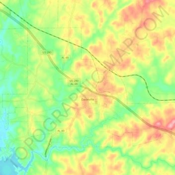
Name: Dadeville topographic map, elevation, terrain.
Location: Dadeville, Tallapoosa County, Alabama, United States (32.80548 -85.81779 32.86960 -85.70654)
Average elevation: 195 m
Minimum elevation: 140 m
Maximum elevation: 260 m
Make a donation
Gear up for your next adventure:
As an Amazon Associate, this site earns from qualifying purchases at no extra cost to you.
Other topographic maps
Click on a map to view its topography, its elevation and its terrain.
Make a donation
Gear up for your next adventure:
As an Amazon Associate, this site earns from qualifying purchases at no extra cost to you.
Camp Hill
United States > Alabama > Tallapoosa County > Camp Hill > Camp Hill
Average elevation: 203 m