Fort Smith topographic map
Click on the map to display elevation.
Fort Smith
The United States acquired the territory and large areas west of the Mississippi River from France in the Louisiana Purchase (1803). Soon after, the government sent the Pike Expedition (1806) to explore the areas along the Arkansas River. The US founded Fort Smith in 1817 as a military post. It was named after General Thomas Adams Smith (1781–1844), who commanded the United States Army Rifle Regiment in 1817, headquartered near St. Louis. General Smith had ordered Army topographical engineer Stephen H. Long (1784–1864) to find a suitable site on the Arkansas River for a fort. General Smith never visited the town or the forts that bore his name.
About this map
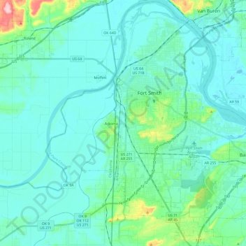
Name: Fort Smith topographic map, elevation, terrain.
Location: Fort Smith, Sebastian County, Arkansas, United States (35.25885 -94.43554 35.44982 -94.25286)
Average elevation: 140 m
Minimum elevation: 114 m
Maximum elevation: 266 m
Other topographic maps
Click on a map to view its topography, its elevation and its terrain.