
Make a donation
Gear up for your next adventure:
As an Amazon Associate, this site earns from qualifying purchases at no extra cost to you.
Chertsey topographic map
Click on the map to display elevation.
Make a donation
Gear up for your next adventure:
As an Amazon Associate, this site earns from qualifying purchases at no extra cost to you.
Chertsey
Samuel Lewis devotes one of his longest entries to the small town in his 1848 topographical guide to England.
Make a donation
Gear up for your next adventure:
As an Amazon Associate, this site earns from qualifying purchases at no extra cost to you.
About this map
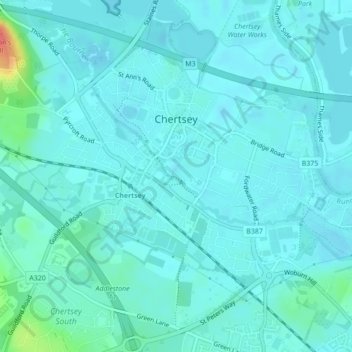
Name: Chertsey topographic map, elevation, terrain.
Average elevation: 17 m
Minimum elevation: 9 m
Maximum elevation: 66 m
Surrey trails, hiking, mountain biking, running and outdoor activities
Make a donation
Gear up for your next adventure:
As an Amazon Associate, this site earns from qualifying purchases at no extra cost to you.
Other topographic maps
Click on a map to view its topography, its elevation and its terrain.
Cooper's Hill Slopes
United Kingdom > England > Surrey > Borough of Runnymede > Englefield Green
Average elevation: 38 m
Make a donation
Gear up for your next adventure:
As an Amazon Associate, this site earns from qualifying purchases at no extra cost to you.
Chertsey
United Kingdom > England > Surrey > Borough of Runnymede
Samuel Lewis devotes one of his longest entries to the small town in his 1848 topographical guide to England.
Average elevation: 22 m
Egham Wick
United Kingdom > England > Surrey > Borough of Runnymede > Englefield Green
Average elevation: 55 m
Make a donation
Gear up for your next adventure:
As an Amazon Associate, this site earns from qualifying purchases at no extra cost to you.
Make a donation
Gear up for your next adventure:
As an Amazon Associate, this site earns from qualifying purchases at no extra cost to you.
Lyn Mushroom Farm
United Kingdom > England > Surrey > Borough of Runnymede > Lyne
Average elevation: 39 m
Make a donation
Gear up for your next adventure:
As an Amazon Associate, this site earns from qualifying purchases at no extra cost to you.
Chertsey
United Kingdom > England > Surrey > Borough of Runnymede
Samuel Lewis devotes one of his longest entries to the small town in his 1848 topographical guide to England.
Average elevation: 22 m
Make a donation
Gear up for your next adventure:
As an Amazon Associate, this site earns from qualifying purchases at no extra cost to you.