
Make a donation
Gear up for your next adventure:
As an Amazon Associate, this site earns from qualifying purchases at no extra cost to you.
Mont Saint-Bruno topographic map
Click on the map to display elevation.
Make a donation
Gear up for your next adventure:
As an Amazon Associate, this site earns from qualifying purchases at no extra cost to you.
About this map
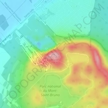
Name: Mont Saint-Bruno topographic map, elevation, terrain.
Average elevation: 85 m
Minimum elevation: 25 m
Maximum elevation: 198 m
Make a donation
Gear up for your next adventure:
As an Amazon Associate, this site earns from qualifying purchases at no extra cost to you.
Other topographic maps
Click on a map to view its topography, its elevation and its terrain.
Mont-Saint-Bruno National Park
Canada > Quebec > Urban agglomeration of Longueuil > Saint-Bruno-de-Montarville
Mount Saint-Bruno is an inselberg that reaches 218 metres (715 ft) in altitude, above a plain with an average altitude of 30 metres (98 ft). Its highest summits are situated on its north-eastern flank and form an ellipse around the "lac des Bouleaux" (Birch Lake). Its outer terrain gradually recedes towards…
Average elevation: 55 m