
Weißensee topographic map
Interactive map
Click on the map to display elevation.
About this map
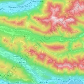
Name: Weißensee topographic map, elevation, terrain.
Average elevation: 1,191 m
Minimum elevation: 556 m
Maximum elevation: 2,210 m
Other topographic maps
Click on a map to view its topography, its elevation and its terrain.
Pusarnitz
Austria > Carinthia > Bezirk Spittal an der Drau > Lurnfeld
Pusarnitz, Lurnfeld, Bezirk Spittal an der Drau, Carinthia, 9812, Austria
Average elevation: 752 m
Pasterze
Austria > Carinthia > Bezirk Spittal an der Drau > Heiligenblut am Großglockner
Pasterze, Heiligenblut am Großglockner, Bezirk Spittal an der Drau, Carinthia, Austria
Average elevation: 2,599 m
Bad Kleinkirchheim
Austria > Carinthia > Bezirk Spittal an der Drau
Bad Kleinkirchheim, Bezirk Spittal an der Drau, Carinthia, 9546, Austria
Average elevation: 1,605 m
Sonnblick
Austria > Carinthia > Bezirk Spittal an der Drau > Lendorf
Sonnblick, Lendorf, Bezirk Spittal an der Drau, Carinthia, 9811, Austria
Average elevation: 2,227 m
Techendorf
Austria > Carinthia > Bezirk Spittal an der Drau > Weißensee
Techendorf, Weißensee, Bezirk Spittal an der Drau, Carinthia, 9762, Austria
Average elevation: 1,183 m
Großkirchheim
Austria > Carinthia > Bezirk Spittal an der Drau
Großkirchheim, Bezirk Spittal an der Drau, Carinthia, Austria
Average elevation: 2,119 m
Heiligenblut am Großglockner
Austria > Carinthia > Bezirk Spittal an der Drau
Heiligenblut am Großglockner, Bezirk Spittal an der Drau, Carinthia, 9844, Austria
Average elevation: 2,236 m
Zlatting
Austria > Carinthia > Bezirk Spittal an der Drau > Trebesing
Zlatting, Trebesing, Bezirk Spittal an der Drau, Carinthia, 9852, Austria
Average elevation: 1,015 m
Greifenburg
Austria > Carinthia > Bezirk Spittal an der Drau
Greifenburg, Bezirk Spittal an der Drau, Carinthia, 9761, Austria
Average elevation: 1,461 m
Rosenberg
Austria > Carinthia > Bezirk Spittal an der Drau > Waidach
Rosenberg, Waidach, Oberdrauburg, Bezirk Spittal an der Drau, Carinthia, 9781, Austria
Average elevation: 888 m
High Tauern National Park
Austria > Carinthia > Bezirk Spittal an der Drau > Heiligenblut am Großglockner
High Tauern National Park, Heiligenblut am Großglockner, Bezirk Spittal an der Drau, Carinthia, 9844, Austria
Average elevation: 1,710 m
Asten
Austria > Carinthia > Bezirk Spittal an der Drau > Mörtschach
Asten, Mörtschach, Bezirk Spittal an der Drau, Carinthia, 9842, Austria
Average elevation: 1,811 m
Mörtschach
Austria > Carinthia > Bezirk Spittal an der Drau
Mörtschach, Bezirk Spittal an der Drau, Carinthia, Austria
Average elevation: 1,851 m
Hadergasse
Austria > Carinthia > Bezirk Spittal an der Drau > Heiligenblut am Großglockner
Hadergasse, Heiligenblut am Großglockner, Bezirk Spittal an der Drau, Carinthia, 9844, Austria
Average elevation: 1,677 m
Heiligenblut
Austria > Carinthia > Bezirk Spittal an der Drau > Heiligenblut am Großglockner
Heiligenblut, Heiligenblut am Großglockner, Bezirk Spittal an der Drau, Carinthia, 9844, Austria
Average elevation: 1,982 m
Maltatal
Austria > Carinthia > Bezirk Spittal an der Drau > Gmünd in Kärnten
Maltatal, Gmünd in Kärnten, Bezirk Spittal an der Drau, Carinthia, 9853, Austria
Average elevation: 1,914 m
Lendorf
Austria > Carinthia > Bezirk Spittal an der Drau > Lendorf
Lendorf, Bezirk Spittal an der Drau, Carinthia, 9811, Austria
Average elevation: 1,235 m
Flattach
Austria > Carinthia > Bezirk Spittal an der Drau > Flattach
Flattach, Bezirk Spittal an der Drau, Carinthia, 9831, Austria
Average elevation: 1,718 m
Waidach
Austria > Carinthia > Bezirk Spittal an der Drau > Waidach
Waidach, Oberdrauburg, Bezirk Spittal an der Drau, Carinthia, 9781, Austria
Average elevation: 846 m
Seeboden am Millstätter See
Austria > Carinthia > Bezirk Spittal an der Drau
Seeboden am Millstätter See, Bezirk Spittal an der Drau, Carinthia, 9871, Austria
Average elevation: 942 m
Mallnitz
Austria > Carinthia > Bezirk Spittal an der Drau
Mallnitz, Bezirk Spittal an der Drau, Carinthia, 9822, Austria
Average elevation: 1,926 m
Spittal an der Drau
Austria > Carinthia > Bezirk Spittal an der Drau
Spittal an der Drau, Bezirk Spittal an der Drau, Carinthia, 9800, Austria
Average elevation: 969 m
Großglockner
Austria > Carinthia > Bezirk Spittal an der Drau > Heiligenblut am Großglockner
Großglockner, Heiligenblut am Großglockner, Bezirk Spittal an der Drau, Carinthia, Austria
Average elevation: 3,128 m