
Make a donation
Gear up for your next adventure:
As an Amazon Associate, this site earns from qualifying purchases at no extra cost to you.
Kanyakumari topographic map
Click on the map to display elevation.
Make a donation
Gear up for your next adventure:
As an Amazon Associate, this site earns from qualifying purchases at no extra cost to you.
Kanyakumari
Kanniyakumari is located at 8°05′N 77°34′E / 8.08°N 77.57°E / 8.08; 77.57. and has an average elevation of 30 metres. The peninsular tip of Kanniyakumari is bordered on three sides by the Laccadive Sea. It is located at the confluence of the Western Coastal Plains and Eastern Coastal Plains.
Make a donation
Gear up for your next adventure:
As an Amazon Associate, this site earns from qualifying purchases at no extra cost to you.
About this map
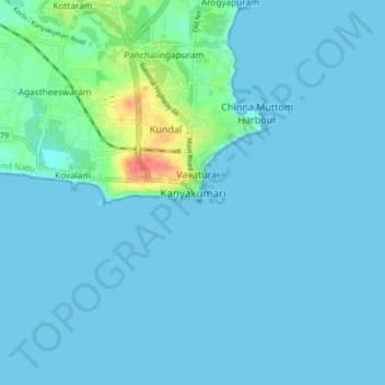
Name: Kanyakumari topographic map, elevation, terrain.
Average elevation: 6 m
Minimum elevation: 0 m
Maximum elevation: 55 m
Make a donation
Gear up for your next adventure:
As an Amazon Associate, this site earns from qualifying purchases at no extra cost to you.