
Halberstadt topographic map
Interactive map
Click on the map to display elevation.
About this map
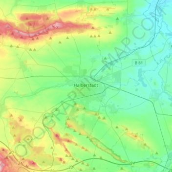
Name: Halberstadt topographic map, elevation, terrain.
Location: Halberstadt, Landkreis Harz, Saxony-Anhalt, 38820, Germany (51.83097 10.88137 51.95717 11.17484)
Average elevation: 149 m
Minimum elevation: 81 m
Maximum elevation: 330 m
Other topographic maps
Click on a map to view its topography, its elevation and its terrain.
Langenstein
Germany > Saxony-Anhalt > Landkreis Harz > Halberstadt
Langenstein, Halberstadt, Landkreis Harz, Saxony-Anhalt, 38895, Germany
Average elevation: 166 m