
Mbale topographic map
Interactive map
Click on the map to display elevation.
About this map
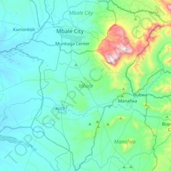
Name: Mbale topographic map, elevation, terrain.
Location: Mbale, Eastern Region, Uganda (0.82909 34.08108 1.17458 34.33769)
Average elevation: 1,268 m
Minimum elevation: 1,072 m
Maximum elevation: 2,336 m
Other topographic maps
Click on a map to view its topography, its elevation and its terrain.
Mbale
Uganda > Mbale > Bugisa sub-region > Mbale
Mbale, Bugisa sub-region, Mbale, Eastern Region, MBALE, Uganda
Average elevation: 1,236 m