Geolocate

Kakching topographic map

Click on the map to display elevation.

About this map

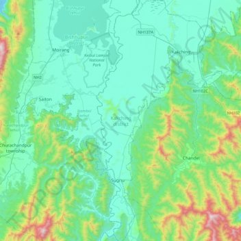
Name: Kakching topographic map, elevation, terrain.

Location: Kakching, Manipur, India (24.20008 93.83808 24.57776 94.05353)

Average elevation: 925 m

Minimum elevation: 703 m

Maximum elevation: 1,897 m

Other topographic maps

Click on a map to view its topography, its elevation and its terrain.

Tuithang

India > Manipur > Tamenglong West

Average elevation: 463 m

Keithelmanbi

India > Manipur > Kangpoki subdivision

Average elevation: 1,039 m

Khoupum

India > Manipur > Nungba

Average elevation: 910 m

Jiribam

India > Manipur > Jiribam tehsill

Average elevation: 40 m

Kwatha Meitei

India > Manipur > Tengnoupal tehsil

Average elevation: 476 m

Senapati

India > Manipur > Senapati tehsil

Average elevation: 1,321 m

Ningthoukhong

India > Manipur > Ningthoukhong

Average elevation: 777 m

Khuga Dam

India > Manipur > Churachandpur

Average elevation: 849 m

Pherzawl

India > Manipur > Tipaimukh

Average elevation: 779 m

Noney

India > Manipur > Tamenglong

Average elevation: 670 m

Kangpokpi

India > Manipur > Kangpoki

Average elevation: 1,328 m

Gear up for your next adventure:

🧢Hiking Hats - Sun and weather protection for outdoor walks
🗺️Ordnance Survey Maps - Essential paper maps for hiking across the UK national parks
Lightweight Solo Tents - Backpacking tents designed for wild camping in the UK highlands
🧭Professional Hiking Compasses - High-precision liquid-filled compasses for map reading and orientation
🛰️Outdoor GPS Navigation - Navigation devices for remote and off-grid areas

As an Amazon Associate, this site earns from qualifying purchases at no extra cost to you.