
Make a donation
Gear up for your next adventure:
As an Amazon Associate, this site earns from qualifying purchases at no extra cost to you.
Dumaguete topographic map
Click on the map to display elevation.
Make a donation
Gear up for your next adventure:
As an Amazon Associate, this site earns from qualifying purchases at no extra cost to you.
Dumaguete
As a coastal city, it is bounded on the east by the Bohol Sea and the Tañon Strait, serving as a natural border of southeastern Negros Island Region to the neighboring Central Visayas. The city's topography is generally flat from two to six kilometers from the shoreline. It slopes gently upwards to the adjoining municipality of Valencia. The highest ground elevation is located at the boundary of the municipality of Valencia, about one hundred meters above mean sea level. About 93% of the land have slopes of less than 3%. The remaining areas have 3% to 5% slope.
Make a donation
Gear up for your next adventure:
As an Amazon Associate, this site earns from qualifying purchases at no extra cost to you.
About this map
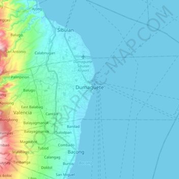
Name: Dumaguete topographic map, elevation, terrain.
Average elevation: 55 m
Minimum elevation: 0 m
Maximum elevation: 500 m
Make a donation
Gear up for your next adventure:
As an Amazon Associate, this site earns from qualifying purchases at no extra cost to you.
Other topographic maps
Click on a map to view its topography, its elevation and its terrain.
Dumaguete
Philippines > Negros Oriental > Dumaguete
As a coastal city, it is bounded on the east by the Bohol Sea and the Tañon Strait, serving as a natural border of southeastern Negros Island Region to the neighboring Central Visayas. The city's topography is generally flat from two to six kilometers from the shoreline. It slopes gently upwards to the…
Average elevation: 167 m
Make a donation
Gear up for your next adventure:
As an Amazon Associate, this site earns from qualifying purchases at no extra cost to you.
Make a donation
Gear up for your next adventure:
As an Amazon Associate, this site earns from qualifying purchases at no extra cost to you.
Make a donation
Gear up for your next adventure:
As an Amazon Associate, this site earns from qualifying purchases at no extra cost to you.