
Liddes topographic map
Interactive map
Click on the map to display elevation.
About this map
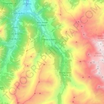
Name: Liddes topographic map, elevation, terrain.
Location: Liddes, Entremont, Wallis, 1945, Switzerland (45.91392 7.12342 46.03428 7.27199)
Average elevation: 2,123 m
Minimum elevation: 875 m
Maximum elevation: 3,665 m
Other topographic maps
Click on a map to view its topography, its elevation and its terrain.
Pied de Ville
Switzerland > Wallis > Entremont > Sembrancher
Pied de Ville, La Gravenne, Sembrancher, Entremont, Wallis, 2303, Switzerland
Average elevation: 960 m
Les Posettes
Switzerland > Wallis > Entremont > Vollèges > Charançon
Les Posettes, Charançon, Vollèges, Val de Bagnes, Entremont, Wallis, 1934, Switzerland
Average elevation: 1,010 m
Val de Bagnes
Switzerland > Wallis > Entremont
Val de Bagnes, Entremont, Wallis, 1934, Switzerland
Average elevation: 2,321 m
Grand Combin de Grafeneire
Switzerland > Wallis > Entremont
Grand Combin de Grafeneire, Val de Bagnes, Entremont, Wallis, 1934, Switzerland
Average elevation: 3,603 m
Aiguille d'Orny
Switzerland > Wallis > Entremont > Orsières
Aiguille d'Orny, Orsières, Entremont, Wallis, 2303, Switzerland
Average elevation: 2,810 m
Verbier
Switzerland > Wallis > Entremont
Verbier, Val de Bagnes, Entremont, Wallis, 1934, Switzerland
Average elevation: 1,626 m
Bourg-Saint-Pierre
Switzerland > Wallis > Entremont
Bourg-Saint-Pierre, Entremont, Wallis, 1946, Switzerland
Average elevation: 2,530 m