
Make a donation
Gear up for your next adventure:
As an Amazon Associate, this site earns from qualifying purchases at no extra cost to you.
Mtskheta topographic map
Click on the map to display elevation.
Make a donation
Gear up for your next adventure:
As an Amazon Associate, this site earns from qualifying purchases at no extra cost to you.
About this map
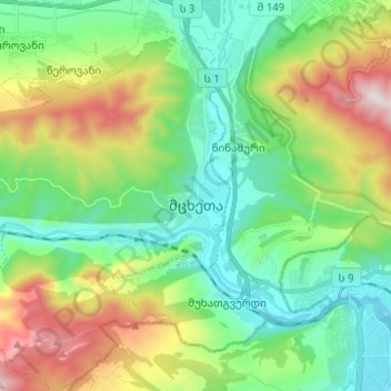
Name: Mtskheta topographic map, elevation, terrain.
Location: Mtskheta, Mtskheta Municipality, Mtskheta-Mtianeti, Georgia (41.80230 44.63253 41.89455 44.73024)
Average elevation: 694 m
Minimum elevation: 422 m
Maximum elevation: 1,297 m
Make a donation
Gear up for your next adventure:
As an Amazon Associate, this site earns from qualifying purchases at no extra cost to you.
Other topographic maps
Click on a map to view its topography, its elevation and its terrain.
Make a donation
Gear up for your next adventure:
As an Amazon Associate, this site earns from qualifying purchases at no extra cost to you.
Make a donation
Gear up for your next adventure:
As an Amazon Associate, this site earns from qualifying purchases at no extra cost to you.
Tskhvarichamia
Georgia > Mtskheta-Mtianeti > Mtskheta Municipality > Tskhvarichamia
Average elevation: 1,199 m