
Glasgow topographic map
Interactive map
Click on the map to display elevation.
Glasgow
According to the United States Census Bureau, the city has a total area of 1.43 square miles (3.7 km2), all land. The town has an elevation of 2,093 feet (638 m). It is nestled in the Milk River Valley with the river itself meandering along to south.
About this map
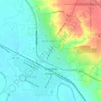
Name: Glasgow topographic map, elevation, terrain.
Location: Glasgow, Valley County, Montana, 59230, United States (48.18836 -106.65042 48.21255 -106.61272)
Average elevation: 654 m
Minimum elevation: 633 m
Maximum elevation: 700 m
Other topographic maps
Click on a map to view its topography, its elevation and its terrain.