
Make a donation
Gear up for your next adventure:
As an Amazon Associate, this site earns from qualifying purchases at no extra cost to you.
Dehradun topographic map
Click on the map to display elevation.
Make a donation
Gear up for your next adventure:
As an Amazon Associate, this site earns from qualifying purchases at no extra cost to you.
Dehradun
The city of Dehradun mainly lies in Doon Valley and is at a varying height from 410 m (1,350 ft) in Clement Town to above 700 m (2,300 ft) at Malsi which is 15 km (9.3 mi) from the city. However, the average elevation is 450 m (1,480 ft) above sea level. Malsi is the starting point of Lesser Himalayan Range that extends to Mussoorie and beyond. Jaunsar-Bawar hills in Dehradun district rises to 3,700 m (12,100 ft) above sea level. The hilly region of Mussoorie goes up to a height of 1,870–2,017 m (6,135–6,617 ft) above sea level. Its geomorphological and meteorological characteristics make it prone to a number of natural hazards. Beside earthquakes, the region is frequently devastated by landslides, cloudbursts, flash-floods, cold waves and hailstorms.
Make a donation
Gear up for your next adventure:
As an Amazon Associate, this site earns from qualifying purchases at no extra cost to you.
About this map
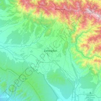
Name: Dehradun topographic map, elevation, terrain.
Location: Dehradun, Uttarakhand, 248001, India (30.16556 77.88368 30.48556 78.20368)
Average elevation: 904 m
Minimum elevation: 402 m
Maximum elevation: 2,568 m
Make a donation
Gear up for your next adventure:
As an Amazon Associate, this site earns from qualifying purchases at no extra cost to you.