
Futuna topographic map
Interactive map
Click on the map to display elevation.
About this map
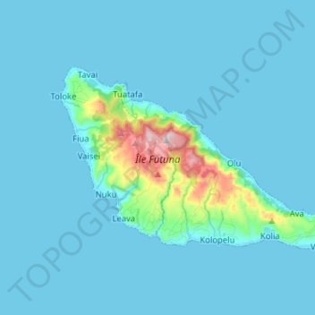
Name: Futuna topographic map, elevation, terrain.
Location: Futuna, Sigave, Wallis and Futuna, 98620, France (-14.31282 -178.18175 -14.24072 -178.05380)
Average elevation: 43 m
Minimum elevation: 0 m
Maximum elevation: 518 m
Other topographic maps
Click on a map to view its topography, its elevation and its terrain.
Leava
France > Wallis and Futuna > Sigave > Leava
Leava, Sigave, Wallis and Futuna, 98620, France
Average elevation: 66 m