
Make a donation
Gear up for your next adventure:
As an Amazon Associate, this site earns from qualifying purchases at no extra cost to you.
North Liberty topographic map
Click on the map to display elevation.
Make a donation
Gear up for your next adventure:
As an Amazon Associate, this site earns from qualifying purchases at no extra cost to you.
North Liberty
North Liberty is located on the Iowan erosion surface. Drivers on I-380 experience an abrupt transition from the muted topography of the Iowan surface to the rolling hills of the Southern Iowa drift plain, four miles south of North Liberty.
Make a donation
Gear up for your next adventure:
As an Amazon Associate, this site earns from qualifying purchases at no extra cost to you.
About this map
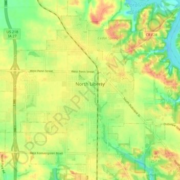
Name: North Liberty topographic map, elevation, terrain.
Location: North Liberty, Johnson County, Iowa, 52317, United States (41.71922 -91.65163 41.77198 -91.56608)
Average elevation: 235 m
Minimum elevation: 206 m
Maximum elevation: 262 m
Make a donation
Gear up for your next adventure:
As an Amazon Associate, this site earns from qualifying purchases at no extra cost to you.
Other topographic maps
Click on a map to view its topography, its elevation and its terrain.
Iowa City
United States > Iowa > Johnson County > Iowa City
The elevation at the Iowa City Municipal Airport is 668 ft (203.6 m) above sea level.
Average elevation: 225 m