
Make a donation
Gear up for your next adventure:
As an Amazon Associate, this site earns from qualifying purchases at no extra cost to you.
Millau topographic map
Click on the map to display elevation.
Make a donation
Gear up for your next adventure:
As an Amazon Associate, this site earns from qualifying purchases at no extra cost to you.
Millau
The territory of this town lies across a southern portion of the Massif Central. It covers a large area of some 16,823 hectares (41,570 acres), which makes it the 25th largest metropolitan town in France. The municipality lies at the heart of the Grands Causses, a part of the Causse Rouge (east of the plateau Lévézou), and part of Larzac as well as part of the Black Causse. The city county seat is located in the lower part of the town, in a large depression at the confluence of the Tarn and Dourbie, at an altitude of about 340 m.
Make a donation
Gear up for your next adventure:
As an Amazon Associate, this site earns from qualifying purchases at no extra cost to you.
About this map
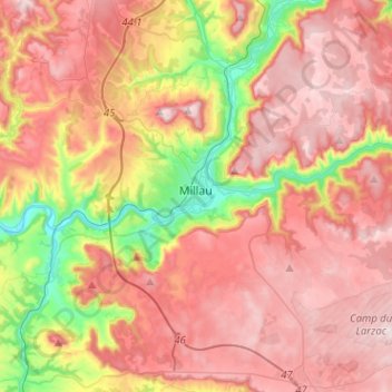
Name: Millau topographic map, elevation, terrain.
Location: Millau, Aveyron, Occitania, Metropolitan France, 12100, France (44.01667 2.99064 44.17985 3.24486)
Average elevation: 656 m
Minimum elevation: 331 m
Maximum elevation: 895 m
Make a donation
Gear up for your next adventure:
As an Amazon Associate, this site earns from qualifying purchases at no extra cost to you.
Other topographic maps
Click on a map to view its topography, its elevation and its terrain.
Make a donation
Gear up for your next adventure:
As an Amazon Associate, this site earns from qualifying purchases at no extra cost to you.
Make a donation
Gear up for your next adventure:
As an Amazon Associate, this site earns from qualifying purchases at no extra cost to you.
Make a donation
Gear up for your next adventure:
As an Amazon Associate, this site earns from qualifying purchases at no extra cost to you.
Make a donation
Gear up for your next adventure:
As an Amazon Associate, this site earns from qualifying purchases at no extra cost to you.