Geolocate

Fairborn topographic map

Click on the map to display elevation.

About this map
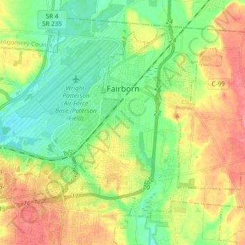
Name: Fairborn topographic map, elevation, terrain.

Location: Fairborn, Greene County, Ohio, United States (39.76724 -84.07915 39.84597 -83.94604)

Average elevation: 272 m

Minimum elevation: 238 m

Maximum elevation: 322 m

Other topographic maps

Click on a map to view its topography, its elevation and its terrain.
Washington Mills

United States > Ohio > Greene County

Average elevation: 263 m

Goes Station

United States > Ohio > Greene County

Average elevation: 282 m

Wrightview

United States > Ohio > Greene County > Fairborn

Average elevation: 269 m

Gear up for your next adventure:

🥾Hiking Boot Waterproofing Wax - Maintain the lifespan of your leather trekking boots
🗺️Scratch-off Peak Maps - Track your progress climbing Munros or Wainwrights
🔦Keychain LED Torches - Emergency backup light for finding gear in your pack
🔥Emergency Fire Starters - Reliable ignition tools for survival situations in damp conditions
🧣Neck Gaiters - Protects against wind and sun on exposed ridges and peaks

As an Amazon Associate, this site earns from qualifying purchases at no extra cost to you.