
Sugpon topographic map
Click on the map to display elevation.
About this map
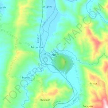
Name: Sugpon topographic map, elevation, terrain.
Location: Sugpon, Ilocos Sur, Ilocos Region, 2717, Philippines (16.80446 120.47672 16.88446 120.55672)
Average elevation: 222 m
Minimum elevation: 42 m
Maximum elevation: 759 m
Other topographic maps
Click on a map to view its topography, its elevation and its terrain.
Candon
Candon City is situated in the lower central portion of the Province of Ilocos Sur. It has a "C" shape with elevations ranging from 10 – 500 ft above sea level. The city is 346 kilometres (215 mi) from Metro Manila and 61 kilometres (38 mi) from Vigan City, the provincial capital.
Average elevation: 83 m