
East Nile topographic map
Interactive map
Click on the map to display elevation.
About this map
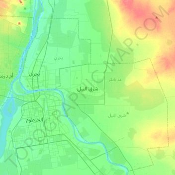
Name: East Nile topographic map, elevation, terrain.
Location: East Nile, Khartoum State, Sudan (15.46104 32.47613 15.78104 32.79613)
Average elevation: 391 m
Minimum elevation: 372 m
Maximum elevation: 436 m
Other topographic maps
Click on a map to view its topography, its elevation and its terrain.
Jebel Aulia Dam
Sudan > Khartoum State > Jebel Aulia
Jebel Aulia Dam, Jebel Aulia, Khartoum State, Sudan
Average elevation: 380 m
Khartoum
Sudan > Khartoum State > Khartoum
Khartoum, Khartoum State, 11111, Sudan
Average elevation: 388 m
The River Nile
Sudan > Khartoum State > Bahri
The River Nile, Bahri, Khartoum State, Sudan
Average elevation: 389 m
Jebel Aulia
Sudan > Khartoum State > Jebel Aulia
Jebel Aulia, Khartoum State, Sudan
Average elevation: 382 m