
Make a donation
Gear up for your next adventure:
As an Amazon Associate, this site earns from qualifying purchases at no extra cost to you.
Kunice topographic map
Click on the map to display elevation.
Make a donation
Gear up for your next adventure:
As an Amazon Associate, this site earns from qualifying purchases at no extra cost to you.
About this map
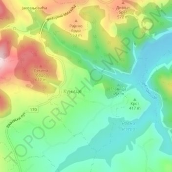
Name: Kunice topographic map, elevation, terrain.
Average elevation: 434 m
Minimum elevation: 302 m
Maximum elevation: 662 m
Make a donation
Gear up for your next adventure:
As an Amazon Associate, this site earns from qualifying purchases at no extra cost to you.
Other topographic maps
Click on a map to view its topography, its elevation and its terrain.
Медведник
Serbia > Central Serbia > Kolubara Administrative District > Suvodanje
Medvednik (Serbian Cyrillic: Медведник) is a mountain in western Serbia, near the town of Valjevo. Its highest peak has an elevation of 1,247 meters above sea level.
Average elevation: 907 m
Краљев сто
Serbia > Central Serbia > Kolubara Administrative District > Mionica Municipality
Average elevation: 982 m
Ljig
Serbia > Central Serbia > Kolubara Administrative District > Ljig Municipality
Average elevation: 222 m
Make a donation
Gear up for your next adventure:
As an Amazon Associate, this site earns from qualifying purchases at no extra cost to you.
Pocuta
Serbia > Central Serbia > Kolubara Administrative District > Valjevo City
Average elevation: 515 m
Колубара
Serbia > Central Serbia > Kolubara Administrative District > Lajkovac Municipality
Average elevation: 128 m