Geolocate

Thabazimbi topographic map

Click on the map to display elevation.

About this map

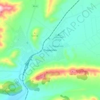
Name: Thabazimbi topographic map, elevation, terrain.

Location: Thabazimbi, Thabazimbi Local Municipality, Waterberg District Municipality, Limpopo, 0380, South Africa (-24.62877 27.37183 -24.54877 27.45183)

Average elevation: 1,077 m

Minimum elevation: 916 m

Maximum elevation: 1,581 m

Other topographic maps

Click on a map to view its topography, its elevation and its terrain.

Gear up for your next adventure:

Lightweight Solo Tents - Backpacking tents designed for wild camping in the UK highlands
🧰Survival Kits - Emergency tools for remote environments
👖Packable Overtrousers - Quick-deploy rain protection for legs in sudden storms
📦Compression Sacks - Reduce backpack volume efficiently
🧭GPS Trackers - Tracking devices for safety and navigation

As an Amazon Associate, this site earns from qualifying purchases at no extra cost to you.