
Ma On Shan topographic map
Interactive map
Click on the map to display elevation.
About this map
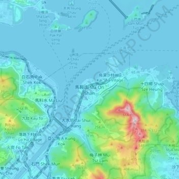
Name: Ma On Shan topographic map, elevation, terrain.
Average elevation: 85 m
Minimum elevation: -4 m
Maximum elevation: 658 m
Other topographic maps
Click on a map to view its topography, its elevation and its terrain.
Kau To
China > Hong Kong > Sha Tin District
Kau To, Sha Tin District, New Territories, Hong Kong, China
Average elevation: 106 m
Sha Tin
China > Hong Kong > Sha Tin District
Sha Tin, Sha Tin District, New Territories, Hong Kong, China
Average elevation: 196 m
Chek Nai Ping Village
China > Hong Kong > Sha Tin District
Chek Nai Ping Village, Sha Tin District, New Territories, Hong Kong, China
Average elevation: 98 m