
Itapevi topographic map
Interactive map
Click on the map to display elevation.
About this map
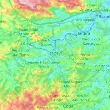
Name: Itapevi topographic map, elevation, terrain.
Average elevation: 814 m
Minimum elevation: 721 m
Maximum elevation: 1,047 m
In 1912, Joaquim Nunes Filho (Nho Quim), from Cotia city, purchased the Sítio Itapevy, with 152 bushels. This place covering all the current city center. Nunes became a local political boss, for his ties to the former PRP (Partido Republicano Paulista). He managed the elevation of the village to district Cotia on October 12, 1920; Nunes has brought electricity in 1929 and the installation of the first telephone in 1930.