
Compiègne topographic map
Interactive map
Click on the map to display elevation.
About this map
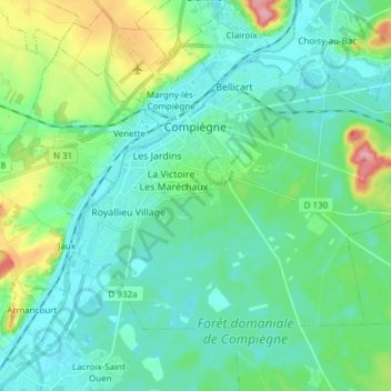
Name: Compiègne topographic map, elevation, terrain.
Average elevation: 54 m
Minimum elevation: 29 m
Maximum elevation: 141 m
Other topographic maps
Click on a map to view its topography, its elevation and its terrain.
Chemin de l'Église
France > Hauts-de-France > Oise > Plainval
Chemin de l'Église, Plainval, Clermont, Oise, Hauts-de-France, Metropolitan France, 60130, France
Average elevation: 114 m
Fond Crépy
France > Hauts-de-France > Oise > Chevincourt
Fond Crépy, Chevincourt, Compiègne, Oise, Hauts-de-France, Metropolitan France, 60150, France
Average elevation: 92 m
Beauvais
France > Hauts-de-France > Oise
Beauvais, Oise, Hauts-de-France, Metropolitan France, 60000, France
Average elevation: 99 m
Saint-Paul
France > Hauts-de-France > Oise
Saint-Paul, Beauvais, Oise, Hauts-de-France, Metropolitan France, 60650, France
Average elevation: 113 m
Ressons-sur-Matz
France > Hauts-de-France > Oise
Ressons-sur-Matz, Compiègne, Oise, Hauts-de-France, Metropolitan France, 60490, France
Average elevation: 76 m
Ville
France > Hauts-de-France > Oise
Ville, Compiègne, Oise, Hauts-de-France, Metropolitan France, 60400, France
Average elevation: 74 m
Noyon
France > Hauts-de-France > Oise
Noyon, Compiègne, Oise, Hauts-de-France, Metropolitan France, 60400, France
Average elevation: 65 m
Saint-Maur
France > Hauts-de-France > Oise
Saint-Maur, Beauvais, Oise, Hauts-de-France, Metropolitan France, 60210, France
Average elevation: 178 m
Crécy
France > Hauts-de-France > Oise > Saint-Sulpice
Crécy, Saint-Sulpice, Beauvais, Oise, Hauts-de-France, Metropolitan France, 60430, France
Average elevation: 117 m
Plainville
France > Hauts-de-France > Oise
Plainville, Clermont, Oise, Hauts-de-France, Metropolitan France, 60120, France
Average elevation: 132 m
Noailles
France > Hauts-de-France > Oise
Noailles, Beauvais, Oise, Hauts-de-France, Metropolitan France, 60430, France
Average elevation: 118 m
Monchy
France > Hauts-de-France > Oise > Rainvillers
Monchy, Rainvillers, Beauvais, Oise, Hauts-de-France, Metropolitan France, 60155, France
Average elevation: 112 m
Senantes
France > Hauts-de-France > Oise
Senantes, Beauvais, Oise, Hauts-de-France, Metropolitan France, 60650, France
Average elevation: 150 m
Baugy
France > Hauts-de-France > Oise > Baugy
Baugy, Compiègne, Oise, Hauts-de-France, Metropolitan France, France
Average elevation: 80 m
Margny-lès-Compiègne
France > Hauts-de-France > Oise > Margny-lès-Compiègne
Margny-lès-Compiègne, Compiègne, Oise, Hauts-de-France, Metropolitan France, 60280, France
Average elevation: 60 m
Bury
France > Hauts-de-France > Oise
Bury, Clermont, Oise, Hauts-de-France, Metropolitan France, 60250, France
Average elevation: 80 m
Verneuil-en-Halatte
France > Hauts-de-France > Oise > Verneuil-en-Halatte
Verneuil-en-Halatte, Senlis, Oise, Hauts-de-France, Metropolitan France, 60550, France
Average elevation: 74 m
Sully
France > Hauts-de-France > Oise
Sully, Beauvais, Oise, Hauts-de-France, Metropolitan France, 60380, France
Average elevation: 166 m
Ferrières
France > Hauts-de-France > Oise
Ferrières, Clermont, Oise, Hauts-de-France, Metropolitan France, 60420, France
Average elevation: 115 m
Clermont
France > Hauts-de-France > Oise
Clermont, Oise, Hauts-de-France, Metropolitan France, 60600, France
Average elevation: 77 m
Pont-Sainte-Maxence
France > Hauts-de-France > Oise
Pont-Sainte-Maxence, Senlis, Oise, Hauts-de-France, Metropolitan France, 60700, France
Average elevation: 56 m
Chaumont-en-Vexin
France > Hauts-de-France > Oise
Chaumont-en-Vexin, Beauvais, Oise, Hauts-de-France, Metropolitan France, 60240, France
Average elevation: 94 m
Boran-sur-Oise
France > Hauts-de-France > Oise
Boran-sur-Oise, Senlis, Oise, Hauts-de-France, Metropolitan France, 60820, France
Average elevation: 44 m
Attichy
France > Hauts-de-France > Oise
Attichy, Compiègne, Oise, Hauts-de-France, Metropolitan France, 60350, France
Average elevation: 98 m