Geolocate

Bellbrook topographic map

Click on the map to display elevation.

About this map
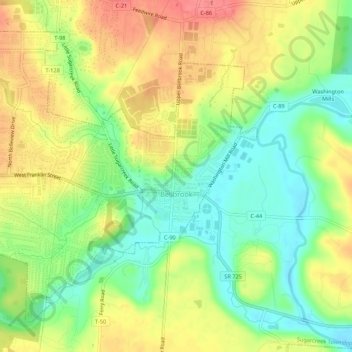
Name: Bellbrook topographic map, elevation, terrain.

Location: Bellbrook, Greene County, Ohio, 45305, United States (39.62069 -84.11178 39.65512 -84.05772)

Average elevation: 262 m

Minimum elevation: 228 m

Maximum elevation: 298 m

Other topographic maps

Click on a map to view its topography, its elevation and its terrain.
Washington Mills

United States > Ohio > Greene County

Average elevation: 263 m

Goes Station

United States > Ohio > Greene County

Average elevation: 282 m

Wrightview

United States > Ohio > Greene County > Fairborn

Average elevation: 269 m

Gear up for your next adventure:

🗺️Ordnance Survey Maps - Official UK maps for walking and outdoor activities
🔋Power Banks - Portable chargers for long outdoor trips
📚UK Hiking Guidebooks - Detailed route descriptions for the Lake District, Peaks, and Highlands
🎒Hiking Backpacks - Comfortable backpacks for day hikes and multi-day treks
🧴Tick Removal Tools - Small, essential health tool for UK woodland and moorland

As an Amazon Associate, this site earns from qualifying purchases at no extra cost to you.