
Krakow topographic map
Interactive map
Click on the map to display elevation.
About this map
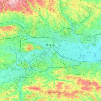
Name: Krakow topographic map, elevation, terrain.
Location: Krakow, Lesser Poland Voivodeship, Poland (49.96767 19.79224 50.12613 20.21735)
Average elevation: 263 m
Minimum elevation: 189 m
Maximum elevation: 469 m
Other topographic maps
Click on a map to view its topography, its elevation and its terrain.
Kościuszko Mound
Poland > Lesser Poland Voivodeship > Krakow
Kościuszko Mound, Plac Paula McCartney'a, Zwierzyniec, Krakow, Lesser Poland Voivodeship, 30-210, Poland
Average elevation: 220 m
Old Town
Poland > Lesser Poland Voivodeship > Krakow
Old Town, Stare Miasto, Old Town, Krakow, Lesser Poland Voivodeship, Poland
Average elevation: 211 m