Geolocate

Giza topographic map

Click on the map to display elevation.

About this map
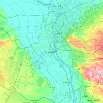
Name: Giza topographic map, elevation, terrain.

Location: Giza, Aj Jiza, 12524, Egypt (29.82708 31.05181 30.14708 31.37181)

Average elevation: 72 m

Minimum elevation: 6 m

Maximum elevation: 330 m

Other topographic maps

Click on a map to view its topography, its elevation and its terrain.

Geziret el Dahab

Egypt > Aj Jiza > Giza

Average elevation: 23 m

Nazlet Al Siman and Al Sisi

Egypt > Aj Jiza > Giza

Average elevation: 42 m

Al Ayat City

Egypt > Aj Jiza

Average elevation: 23 m

Memphis

Egypt > Aj Jiza > Mit Rahinah

Average elevation: 23 m

Gear up for your next adventure:

🔦LED Camping Lanterns - Illumination for reading maps inside your tent at night
🧦Hiking Socks - Breathable socks designed to prevent blisters on long walks
🔋Solar Chargers - Eco-friendly charging solutions for outdoor use
👟Waterproof Leg Gaiters - Keep mud and water out of your boots in boggy terrain
🩹Hiking First Aid Kits - Compact medical kits tailored for trail injuries and emergencies

As an Amazon Associate, this site earns from qualifying purchases at no extra cost to you.